Withernwick Village Website
The Website for Withernwick people and anyone else
Hobbies, Interests &
Activities
Items for Sale / Wanted
About Withernwick & the Website
The Geography of the Holderness
| What we want here are articles on the
geography and geology of the Withernwick and Holderness area. If you have any such information send it to us via the contact us page. |
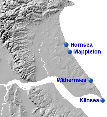
| Here is a map
showing the topography of Holderness, as you can see Withernwick is on
land slightly higher than the land around the River Hull. Most of
Withenwick is 10 to 15 m above sea level, the land around the River Hull
goes down to sea-level. You can clearly see the (relatively) much higher
land that forms the Wolds, you can tell this as you drive out of Beverley,
across The Westwood and into Walkington. Indeed before the last Ice Age,
the white cliffs of Flamborough Head would have continued round the
line marked by the Eastern edge of the high ground. |

| The geography and Geology of Withernwick is
essentially the same as that of Holderness. Holderness is one of the
newest bits of Britain, it only appeared at the end of the last Ice
Age about 20000 years ago, a few seconds in geological time. Also
due to the soft and fragile nature of the Holderness it will also be
one of the first bits to disappear. At present estimates,
Withernwick will become Withernwick-on -Sea in somewhere between
1000 and 2000 years time. Not that that will worry any of us, but
just think - The Falcon could become the Sea View Hotel and
Withernwick might gain a Big Wheel and an amusement arcade! But, of course, the fun and excitement would only be short lived. In a further 200 years or so Withernwick would have finally disappeared into the sea. |
|
If you want to know more about the geography and geology of Withernwick and Holderness, here are a few websites that might be of interest. Just
to start us off here is a link to a website with lots of photos of the
Holderness coast Geology
of Holderness Coastal
Erosion Very
detailed description of the geology of Holderness. Some Videos of the Holderness Coastline
|